
Station Information
What is a SNOTEL site?
A SNOTEL (Snow Telemetry) site is an automated snowpack and weather monitoring station operated by the Natural Resources Conservation Service in the western United States. These sites collect data on precipitation, snow depth, snow water equivalent, temperature, and other meteorological parameters in real-time. SNOTEL sites are typically located in remote or mountainous areas where the bulk of the snowmelt-driven water supply originates.
What is a Snow Course?
A Snow Course is a manually measured snow survey site managed by the NRCS. It consists of a series of permanent, marked measurement points along a designated transect. Snow Courses typically have snow surveyors visit these sites during the last week of each month during the snow season to measure snow depth and snow water equivalent (SWE) at each point, manually recording the data. The snow density is also calculated for each sample point (density = snow water equivalent / snow depth).
How many snow survey stations exist?
There are currently over 1,100 active snow courses and over 850 active SNOTEL sites in 12 western states including Alaska. Montana has 104 active Snow Courses and 96 SNOTEL sites. Those numbers continue to grow as the NRCS Snow Survey offices continue to expand the network in an effort to improve water supply forecasting and make more hydrologic data available to all water users.
Where are NRCS snow survey stations (SNOTEL and Snow Course) located?
SNOTEL and Snow Course sites are located in the western United States, primarily in mountainous regions. They are strategically placed to monitor snowpack and water resources in various watersheds. Typically, the stations are located in forested locations at mid-mountain elevations where environmental inputs to the snowpack remain relatively consistent from year to year. For example, SNOTEL sites are not typically located in alpine settings because wind can transport snow significantly from day to day, resulting in a measurement of what the wind did rather than how much snow fell this season. While valley snowpack has an important role in the efficiency and timing of snowmelt, the bulk of snowpack exists in the mountains, which is primarily where NRCS snow survey stations are located. Valley snowpack is monitored by other agencies such as the National Weather Service and Montana Climate Office.
How often is data collected and transmitted?
Data from SNOTEL sites are collected and transmitted hourly and made available online generally within the hour. Most SNOTEL sites in Montana transmit using GOES satellite transmitters. The NRCS snow survey server processes GOES transmission data at 00:40:00 each hour, which is when the data becomes available online. Roughly 25% of SNOTELs in Montana transmit using cellular technology, which is processed and made available at 00:05:00 each hour. Snow Course data is collected manually during the last 5 business days of each month. The measurement schedule varies per snow course. Most are measured 3 times per year (around March 1, April 1, and May 1), while some are measured 6 times per year (January 1 through June 1), and some are only measured once (either April 1 or May 1).
What maintenance and calibration are required on snow survey stations?
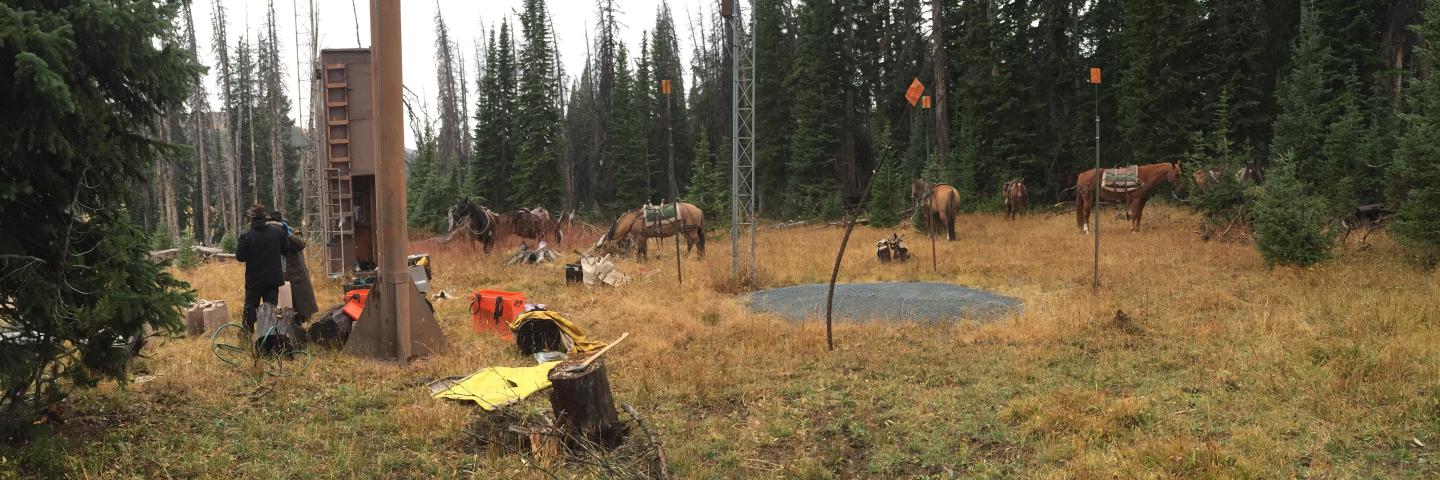
Snow survey stations require annual maintenance to ensure accurate data collection. Annual maintenance generally occurs from May through October and is scheduled during the snow-free season. Maintenance typically includes calibrating and recharging instruments, replacing sensors for preventative maintenance, ensuring transmitters are functioning properly, and managing vegetative encroachment.
How do I access snow survey station (SNOTEL and Snow Course) coordinates?
Snow survey station coordinates are available on the NWCC Report Generator. A predefined link to those coordinates on the NWCC Report Generator can be found on the Montana Station Metadata and Information webpage.
Data Help
How do I access snow survey data?
Snow survey data can be accessed through the NRCS website, which provides access to historical and real-time data from SNOTEL and Snow Courses. Several applications are available for viewing the data including the Interactive Map, Report Generator, and Update Report. Predefined links are available on the Montana Snow Survey Current Conditions webpage to help get you started using the Interactive Map. NRCS Snow Survey products and tools for viewing data have a lot of capabilities and can be confusing. Please contact us at mt-nrcs-snow@usda.gov with questions regarding data access or interpretation.
What is snow water equivalent?
Snow Water Equivalent (SWE) is a term used in hydrology to describe the amount of water contained in a snowpack. It represents the depth of water that would result if the entire snowpack were to melt instantaneously. In other words, it quantifies the water content of the snow. SWE is typically measured in inches or millimeters and is an essential parameter for assessing water resources in regions with seasonal snowfall. It is crucial for understanding potential runoff and its contribution to rivers and reservoirs when the snowpack melts.
A snow survey station or basin is suddenly reporting a high snowpack percent of normal even though it was a generally low snow year. Is that percentage real?
Yes, it is real, however when assessing the snowpack after peak snow water equivalent has occurred (April/May/June) it is important to look at the entire season's snowpack. A snowpack percentage in the late springs doesn't necessarily represent what occurred earlier in the season. Snow water equivalent (SWE) as a percent of median is calculated by dividing a given day's SWE by that day's median SWE. High snowpack percentages are common during the start and end of the snow season when median SWE values are small. For example, median SWE on June 1st might be 0.3 inches. 2 inches of SWE that day would equal 667% of normal snowpack. The snowpack at some locations in Montana can peak at 50 inches of snow water equivalent in April or May. In terms of overall water supply, 1.7 inches more SWE than normal on June 1 is likely not as relevant as a 10-inch SWE deficit in April.
Why is SNOTEL data always 1-2 hours behind current local Montana time?
All SNOTEL sites report data in Pacific Standard Time (PST) all year. The time never changes in the data logger clock. In Montana, SNOTEL sites will appear to be 2 hours behind during Mountain Daylight Time (summer) and 1 hour behind during Mountain Standard Time (winter). For example, when the SNOTEL site collects a reading at 7:00 am local time in Montana during the winter, the data logger will stamp that reading 6:00 am, which is what is reported online. It also takes up to 40 minutes for the data to be processed and made available online. The reading taken at 7:00 am MST (labeled 6:00 PST) might not appear online until 7:40 am.
Which NRCS snow survey data are reviewed, and how often is it reviewed?
SNOTEL sites collect and transmit data hourly; however, only midnight readings (00:00) are thoroughly reviewed and edited. Hourly readings assist with the review process, but in general, only the midnight readings are edited. During the winter, SNOTEL data is reviewed daily on business days. During the summer, SNOTEL data is reviewed weekly. In general, only standard SNOTEL data is edited (snow water equivalent, precipitation, snow depth, air temperature). Extra sensor data is not currently edited (wind, soil moisture/temperature, relative humidity, solar radiation). Snow courses are measured once a month during the winter. All snow course data is reviewed and typically available online by the 5th business day of each month. Please contact mt-nrcs-snow@usda.gov for data-related questions.
The Interactive Map and Report Generator have the option to select either “First of Day” or “End of Day” values. What is the difference?
There is no difference. They are both midnight readings (00:00). Selecting “End of Day” today will result in the same value as “First of Day” tomorrow. For monthly data, you can select either “End of the Month” or “First of Month”, which are also the same.
Why is the snow depth reading blank or an invalid number?
Snow depth sensors are mounted above the snow pillow on the end of a horizontal pipe located on a tower. They are mounted high above the snow pillow, so they don’t get buried in the snow. The sensor takes measurements by sending a sound wave or signal from the sensor to the snow surface. That signal reflects off the surface of the snow and returns to the sensor. The sensor measures the time for that signal to return and calculates the distance between the sensor and surface using the speed of sound. The speed of sounds varies with temperature, and that adjustment is factored into the calculation. Blank or invalid readings are common while it is snowing or windy because the sound wave is blocked or scrambled and doesn’t return to the sensor. As an alternative, estimate snow depth using snow water equivalent, which is a much more reliable measurement. A common density for freshly fallen snow is 10%; therefore, a snow water equivalent increase of 0.1 inch typically results in 1 inch of freshly fallen snow.
Why is the snow depth under reporting new snowfall?
The snowpack naturally settles as the season progresses. Settlement occurs slowly while snow crystals change shape and metamorphosize. Freshly fallen snow is heavy, and settlement occurs more rapidly in the existing snowpack from that newly added weight. For example, it might have snowed 24 inches, but the snow depth is only reporting 15 inches of new snow because the entire snowpack settled 7 inches. This is called in-storm settlement and is the reason snow water equivalent increase can be a more accurate indication of how much it snowed during large storms.
What is the NRCS Montana Water Supply Outlook Report and when is it published?
NRCS Montana Water Supply Outlook Reports (WSOR) are available by the fifth business day of each month from January through June. The report summarizes current conditions related to water supply across Montana, including precipitation, snowpack, temperature, streamflow, drought status, and weather outlooks. It also contains the most recent water supply forecasts for the upcoming spring and summer season.
How do I access NRCS snow survey data via API or Web Service?
The NRCS AWDB (Air-Water Database) Web Service provides methods for programmatically accessing data, metadata (elements, units, stations, etc.), 30-Year Normals, and water supply forecasts. AWDB data can also be accessed via REST API.
Other
Does the snow survey program operate year-round?
Yes, the snow survey program operates year-round. The summer season is primarily field-based and is when annual SNOTEL site maintenance occurs. There are many SNOTEL sites to visit during the snow-free season, and our staff is relatively small. Please be patient if trying to contact us during summer months. The winter season is primarily office-based and is when data analysis and report preparation occur. SNOTEL sites are located where winter weather conditions are harsh, and they do occasionally experience issues, which require onsite visits. Other winter field work involves measuring snow courses during the last week of each month.
How do I request a new SNOTEL location?
The NRCS Montana Snow Survey program is actively expanding the SNOTEL network. The need for new stations is high, but our priority is to keep our existing network maintained. Our current capacity allows for the installation of 1 to 2 SNOTEL sites per year, but that can vary depending on existing needs and upgrades. Please contact mt-nrcs-snow@usda.gov, and we will setup a time to discuss your SNOTEL needs.
Who do I contact to setup a presentation at a local event or school?
All Montana Snow Survey employees are currently located in Bozeman or its surrounding communities, but we are willing to travel for speaking engagements. Typical presentation topics include a general snow program overview, how to access data and utilize snow survey products and tools, current condition updates, and water supply outlooks. Email us at mt-nrcs-snow@usda.gov or give us a call to discuss presentation ideas or to set up a presentation.
Who do I contact for snow survey or water supply related media inquiries?
Montana’s media liaison is Eric Larson. He can be reached at eric.larson@usda.gov. If unavailable, you can send an email to the Montana Snow Survey group email at mt-nrcs-snow@usda.gov.