
Report Generator
Report Generator is a web application developed by the Natural Resources Conservation Service (NRCS) National Water and Climate Center (NWCC). It uses long-term snowpack, precipitation, reservoir, streamflow, and soils data from a variety of quality-controlled sources to create reports.
About Report Generator

Report Generator is a web application developed by the Natural Resources Conservation Service (NRCS) National Water and Climate Center (NWCC).
The application uses long-term snowpack, precipitation, reservoir, streamflow, and soils data from a variety of quality-controlled sources to create reports.
Users can choose from predefined templates or build custom reports.
Data from tabular reports may be exported to different formats, including comma-separated value (CSV) files. Charts can be saved to graphics formats, such as JPG and PNG.
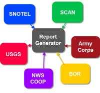
The Report Generator network incorporates data from many agency databases. The NRCS snow survey flagship database, the Water and Climate Information System (WCIS), provides a wealth of data, including manually-collected snow course data and information from automated Snow Telemetry (SNOTEL) and Soil Climate Analysis Network (SCAN) stations across the United States.
Report Generator also uses precipitation, streamflow, and reservoir data from the U.S. Army Corps of Engineers (USACE), the U.S. Bureau of Reclamation (BOR), the Applied Climate Information System (ACIS), the U.S. Geological Survey (USGS), various water districts and other entities.

In addition to creating reports, Report Generator lets you view information on sites, including "metadata," such as elevation, latitude/longitude and hydrologic unit code (HUC).
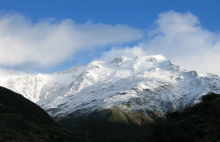
View photos of the site, including a site map (in Google maps when available).
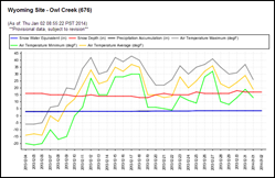
Report Generator creates reports in both tabular and chart format. Single-station and multiple-station charting is also supported. Data may be displayed in either English or Metric units.

Who can benefit from using these data and products?
Farmers, municipalities, water and hydroelectric utilities, environmental organizations, fish and wildlife managers, tribal nations, reservoir managers, recreationists, wetlands managers, urban developers, transportation departments, and research organizations regularly use our data
Water Supply Forecasting
Learn more about Water Supply Forecasting. Forecasting of expected streamflow is an important aid in planning water storage and release as well as agricultural planting decisions.
National Water and Climate Center
The National Water and Climate Center (NWCC) administers the Snow Survey and Water Supply Forecasting Program (SSWSF) and the Soil Climate Analysis Network, and manages the Water and Climate Information System.
Publications of the National Water and Climate Center
Articles, reports, and help files published by the National Water and Climate Center and the Snow Survey and Water Supply Forecasting Program.
Water Supply Forecast Predefined Reports
Predefined links for a variety of water supply forecast reports.
Snow and Climate Monitoring Predefined Reports and Maps
The National Water and Climate Center provides a number of predefined reports, using the online tools it administers for the Snow Survey and Water Supply Forecasting Program.