
The wealth of Illinois is in her soil and her strength lies in its intelligent development.
This quote by Andrew Sloan Draper, President of the University of Illinois (1898-1904), shows the importance we have as stewards of some of the best soil the Earth has to offer.
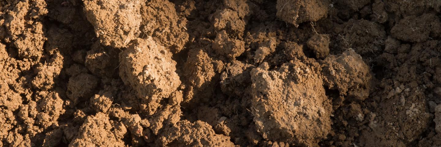
Several processes occurred over hundreds of thousands of years to give us the prime agricultural soil we have today. Multiple enormous glaciers covered much of the state, pushing soil with them from up North. Windblown soil from West of the Mississippi was blown our direction contributing more to our topsoil.
This work over millions of years could easily be destroyed through erosion. It takes hundreds to thousands of years to build an inch of topsoil. It is our responsibility to ensure this resource the Earth worked so hard to provide doesn’t get washed away.
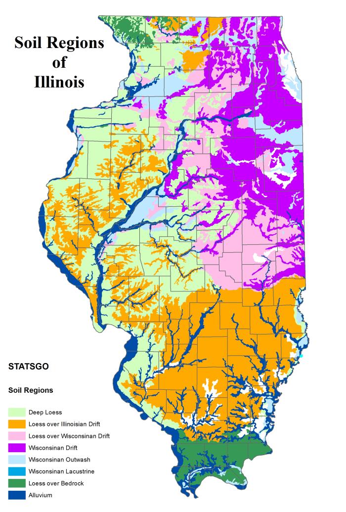
Deep Loess
Tama
Muscatine
Sable
Fayette
Stronghurst
Traer
Alford
Hosmer
Herrick
Lax
Grantsburg
Wisconsinan Drift
Frankfort
Markham
Miami
Varna
Loess over Illinoian Drift
Ava
Bluford
Cisne
Darmstadt
Hickory
Hoyleton
Wynoose
Loess over Wisconsinan Drift
Catlin
Drummer
Flanagan
Russell
Xenia
Wisconsinan Outwash
Bloomfield
Casco
Warsaw
Waupecan
Wisconsinan Lacustrine
Del Rey
Residuum
Derinda
Dubuque
Elizabeth
Gosport
Lacrescent
Lamoille
NewGlarus
Illinois Suite of Maps
We have a wide variety of Illinois maps with information for producers and conservationists.
- Drainage Class
- Floodplains
- Hydric Soils
- Potential Native Vegetation
- Potential Tile Drainage Extent
- Prime Farmland
- Productivity Index
- Soil Order
These maps were produced from data available from the USDA-Natural Resources Conservation Service Soil Data Mart. Please send your comments to Ron Collman, State Soil Scientist.

Illinois State Soil
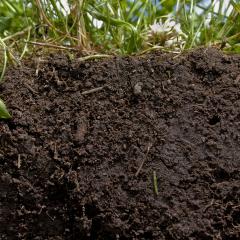
On August 2, 2001, Illinois' Governor signed legislation designating Drummer silty clay loam as the official state soil of Illinois. Drummer is the most extensive and agriculturally productive soil in Illinois according to the Illinois Soil Classifiers Association.
The Drummer soils formed under a luxuriant growth of marsh grasses and sedges, that was typical of much of the native prairie at the time of settlement. Soils formed under prairie vegetation are normally dark colored and high in organic matter content. Illinois is known for its "black dirt" with Drummer silty clay loam being the most common.
The Drummer soil series consists of very deep, poorly drained soils that formed in 40 to 60 inches of loess or other silty material and in the underlying stratified, loamy glacial outwash; under native prairie vegetation. Drummer soils are on nearly level or depressional positions on till plains and outwash plains throughout northern and central Illinois. Typically, Drummer soils have a thick, black silty clay loam surface layer and a very dark gray silty clay loam subsurface layer. The subsoil is grayish brown and gray silty clay loam. The substratum is dark gray, mottled, stratified loam and sandy loam.
Illinois Soil Health
The Illinois Soil Health webpage has soil tech notes, soil health success stories, cover crop economics, and educator resources including a soil video game.
Soil Tech Notes
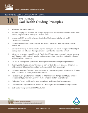
- Soil Tech Note 1A- Soil Health Guiding Principles
- Soil Tech Note 2A- Soil Assessment
- Soil Tech Note 3A- Surface Layer
- Soil Tech Note 4A- Soil Structure
- Soil Tech Note 5A- What the Bugs Do
- Soil Tech Note 6A- Bacteria
- Soil Tech Note 7A- Fungi
- Soil Tech Note 8A- Actinomycetes
- Soil Tech Note 9A- Large Microbes
- Soil Tech Note 10A- Earthworms
- Soil Tech Note 11A- Biological Underground Community
- Soil Tech Note 12A- Soil Organic Matter (SOM)
- Soil Tech Note 13A- Types of Organic Matter (SOM)
- Soil Tech Note 14A- Residue Accumulation
- Soil Tech Note 15A- Cation Exchange Capacity
- Soil Tech Note 16A- Compacted Zone in Soil
- Soil Tech Note 17A- Soil Respiration
- Soil Tech Note 18A- Crop Diversity
- Soil Tech Note 19A- Baby Steps
- Soil Tech Note 20A- "So how do we mess it up??"
- Soil Tech Note 21A- "If you get the chance..."
- Soil Tech Note 22A- Rhizophere
- Soil Tech Note 23A- Carbon:Nitrogen Ratio (C:N)
- Soil Tech Note 24A- pH
- Soil Tech Note 25A- Soil Health Management Systems (SHMS)
Español
- Nota técnica del suelo 2A- Evaluación de suelos
- Nota técnica del suelo 3A- Capa superficial
- Nota técnica del suelo 11A- Comunidad biológica subterránea
- Nota técnica del suelo 12A- Materia orgánica del suelo
Português
- Nota Técnica do Solo 2A- Avaliação do solo
- Nota Técnica do Solo 3A- Camada superficial
- Nota Técnica do Solo 11A- Comunidade Subterrânea Biológica
- Nota Técnica do Solo12A- Matéria Orgânica do Solo
If you would like a PDF version of these, please email Paige Buck, State Public Affairs Specialist.
Educator Resources
Scoop on Soil
Want students to learn how AMAZING soil is? Let ‘Claude,’ (Illinois’ soil clod) do it for you. Claude’s Scoop on Soil is a fun, interactive digital game that teaches the important role soil plays in our lives. Learn how farmers can stop erosion and protect precious soil resources for the future.
Cover Crop Economics
The Cover Crop Economics Tool is a user-friendly economic assessment tool to assess the costs and benefits of incorporating cover crops into a crop rotation. The tool assesses both the short term and long term expected costs and benefits. If you have any problems accessing the tool from this site, using the tool, or if you are interested in being added to an email list to be notified when updated versions of the tool are released, please contact Dr. Stacy Zuber.
Cover Crop$ Tool: An Economic Decision Support Tool- One page flyer that provides a brief description and overview of the Cover Crop Economics Tool
Cover Crop Economics Tool Demonstrations- On demand video replays demonstrating the Cover Crop Economics Tool.
Conservation Discussions
Cover Crops - Experiences From a Retired Educator-Michael Plumer shares some of his unpublished research data.
Cover Crops—Cost and Management Considerations A General Overview
Soil Data
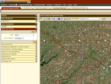
Web Soil Survey
Web Soil Survey (WSS) provides soil data and information produced by the National Cooperative Soil Survey. It is operated by the USDA Natural Resources Conservation Service (NRCS) and provides access to the largest natural resource information system in the world. NRCS has soil maps and data available online for more than 95 percent of the nation’s counties and anticipates having 100 percent in the near future. The site is updated and maintained online as the single authoritative source of soil survey information.
Soil Series Extent Mapping Tool
The SEM Tool provides interactive national maps of soil series and other soil taxon extents based on the land area of mapped series.
RUSLE2
RUSLE2 is a computer model containing both empirical and process-based science in a Windows environment that predicts rill and interrill erosion by rainfall and runoff.
USE1 Soil Key
This soil key incorporates soils mapped in the state of Illinois with parent material, surface color and thickness, drainage class, and other unique attributes.
USE1 Alphabetical Reference Key
This Alphabetical Key is used to help find soils in the Soil Key. This soil key incorporates soils mapped in the state of Illinois with parent material, surface color and thickness, drainage class, and other unique attributes.
USE1 Numerical Reference Key
This Numerical Key (by Soil Map Unit Symbol) is used to help find soils in the Soil Key. This soil key incorporates soils mapped in the state of Illinois with parent material, surface color and thickness, drainage class, and other unique attributes.
Soil Surveys
WHAT IS A SOIL SURVEY?
A soil survey is very simply an inventory of one of our most basic natural resources--the soil. A soil survey report contains maps which show the distribution and extent of soils in an area. The narrative describes the soils and provides interpretations concerning the use and management of each soil for such uses as agriculture, forestry, recreation, building site development, and sanitary facilities. A soil survey is a fundamental tool to sound soil and water management, crop production, and land use.
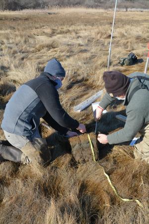
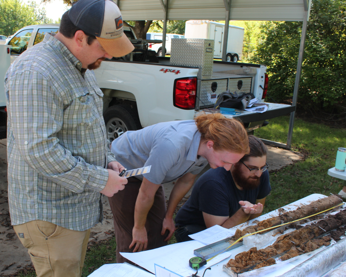
To make a soil survey, soil scientists walk across the land making field observations. They observe slopes, vegetation, and every feature they believe might affect use of the soil. They dig many holes to expose soil profiles, and they record information about the characteristics of the profiles they study to classify and name the soils. Boundaries of the individual soil areas are plotted on aerial photographs.
While a soil survey is in progress, samples of soils are taken as needed for laboratory measurements and engineering tests. This work is done in addition to the field tests made to identify the soils and check interpretations of their behavior during the course of the survey. The mass of soils information is finally organized into a soil survey publication.
STATUS OF SOIL SURVEYS
Soil survey work in Illinois began in 1902. By 1929 the "first generation" soil survey of the state was complete. Since 1953, "second generation" soil surveys have been published for more than 70 of Illinois' 102 counties. Soil mapping was completed in Jefferson County this year (1995), making detailed soil survey information available for the entire state. (See attached status map.)
The objective of the soil survey program in Illinois is to provide a soil survey of the state that is complete, current, and meets the needs of the users. Though we now have a complete survey, it consists of a medley of county reports, completed over a 40 year period, and published at various scales. So, the inventory is not current in every county, and not all of the soil surveys meet users needs.
An update/maintenance program has been initiated that will bring the patchwork of county soil surveys to a common, state-of-the-art standard. A digital soil survey of Illinois is the "next generation" product.
SOIL SURVEY INFORMATION
Fortunately, we in Illinois have many types of good soils. Given the quality and quantity of information available on soil in Illinois, there can be no justification for the inappropriate use of soil for farming, forestry, housing, recreation, industrial development or any other purpose. Soil surveys provide all users with information about their soils and how to manage them properly. It contains predictions of soil behavior for selected land uses. The survey also highlights limitations and hazards inherent in the soil. Improvements needed to overcome the limitations, and the impact of selected land uses on the environment.
The soil survey can be a valuable aid in the future orderly development of agriculture, commerce, and industry in an area. It guides one in using the land intelligently and strengthens our ability to support an ever growing population.
Some users of soil survey information:
- Farmers and Farm Managers use basic soil facts in order to manage the soils on their farms for profitable crop production.
- Engineers want a thorough knowledge of the soils to help locate and design highways and airports, radio and radar stations, dams and reservoirs, foundations - and to plan for flood control, drainage, and irrigation.
- Land Appraisers have many reasons for wanting soils information. Equitable land evaluations are important for making loans and investments, selecting home and business sites, and for equalization of tax assessments.
- Foresters and Woodland Owners want to know the yield potential of the land for specific kinds of timber. They can plan better forest management programs when the timber producing potential of the soil is known. Soil survey information is very helpful in selecting areas for tree planting and in deciding which tree species to plant.
- Manufacturers of fertilizers, farm supplies, and farm equipment can use soils information to locate potential markets for their products. They are also, interested in building and supporting a "permanent" agriculture.
- Zoning and Planning Commissions find basic soil facts helpful in guiding the "urbanization" of our land. Aerial maps provide a basis for planned land use and development in the best interest of the public.
- Investors find soil surveys and the interpretations that accompany them very helpful in determining the soundness of proposed investments. Anyone purchasing a farm needs to know the production potential of the soils.
- Real Estate Dealers, Home Builders, and Sub-dividers must worry about such things as good foundations, adequate drainage, operation of septic tank fields, preparation of lawns, and selection of shrubbery. Soil facts help solve such problems.
- Watershed Planning Groups use soils information to guide their action programs in watershed development, determine watershed problems, and inform the community of possible solutions.
- Canneries and Processors want to locate their plants where they can be assured of a reliable source of raw materials. Are there enough farms with soils suitable for growing fruits and vegetables, corn, potatoes, navy beans, or sugar beets? Soil facts help provide the answers.
- Highway Departments and Railroads need to know basic soil facts along highway and rail routes; how soils need to be handled; effects of freezing and thawing; how to stabilize slopes and future drainage needs.
- Oil and Gas Companies use soils information to locate and design pipelines and plan for erosion control along the right-of-way. Telephone and power companies have similar needs for soils data.
- Credit Agencies often want to know the earning power of farms as determined by their soils. Banks and other lending agencies use soil facts as a basis for making loans and stable arrangements for repayment.
- Wildlife Workers find soil surveys helpful in planning wildlife area improvements; designing and constructing ponds' and locating recreation, hunting, and fishing sites.
- Public Officials must acquire land for schools, parks, reservoirs, and other purposes. Soils information can be quite helpful in determining suitability, cost, and construction details.
Resources
Other Soil Resources
Soils Information. Helping People Understand Soils
Soil Education
SOILWEB APP
Illinois Urban Manual
eFOTG: NRCS electronic Field Office Technical Guide
University of Illinois Soil Productivity Publications
Cooperators, Partners, and Organizations
University of Illinois, College of Agricultural, Consumer and Environmental Sciences
Illinois Department of Agriculture
Illinois State Geological Survey
Illinois Department of Transportation
USDA Forest Service
Illinois Cooperative Extension Service
Association of Illinois Soil and Water Conservation Districts
Illinois Soil Classifiers Association
County Boards of Commissioner
U.S. Geological Survey
Illinois Natural History Survey
Illinois Department of Natural Resources
Soil Science Society of America
Smithsonian National Museum of Natural History
NASA Soils
Additional Links
Soils, Geospatial, Field Office, QAR and related other links